CW30382
Garmin
Garmin BlueChart® g3 Vision® HD - VUS031R - Southwest Caribbean - microSD™/SD™
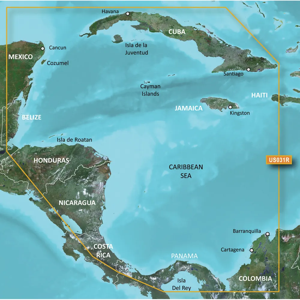
<p><strong>BlueChart® g3 Vision® HD - VUS031R - Southwest Caribbean - microSD™/SD™</strong></p><p><strong>Coverage:</strong></p><p>Detailed coverage of the Caribbean coast of Central America from Cancun, Mexico to Barranquilla, Colombia including coverage of Cuba, Jamaica, the Cayman Islands, Cozumel, San Andres and Providencia, Lake Izabal and the Rio Dulce, the entire Panama Canal and northern reaches of the Gulf of Panama. </p><p><strong>Premier Coastal Navigation Charts</strong></p><ul><li>Provides industry-leading coverage, clarity and detail with updated coastal charts that feature integrated Garmin and Navionics® data</li><li>Auto Guidance¹ technology uses your desired depth and overhead clearance to calculate routes and show a suggested path to follow</li><li>High-resolution relief shading combines color and shadow to give you an easy-to-interpret, clearer view of bottom structure than contour lines alone</li><li>Depth Range Shading provides up to 10 depth ranges, enabling you to view your target depth at a glance</li><li>Up to 1’ contours provide a more accurate depiction of the bottom structure for improved fishing charts and navigation in swamps, canals and marinas</li></ul><p>Experience unparalleled coverage and brilliant detail on the water. BlueChart g3 Vision coastal charts provide industry-leading coverage, clarity and detail with integrated Garmin and Navionics data, Auto Guidance technology and high-resolution relief shading..</p><p><strong>Auto Guidance Technology</strong></p><p>The Auto Guidance feature¹ uses your desired depth and overhead clearance to calculate a route and a suggested path to follow.</p><p><strong>High-resolution Relief Shading Feature</strong></p><p>High-resolution relief shading combines color and shadow to give you an easy-to-interpret, clearer view of bottom structure than contour lines alone.</p><p><strong>Up to 1’ Contours</strong></p><p>The closer the contour lines, the more accurate the depiction of the bottom structure for improved fishing charts and navigation in swamps, canals and marinas.</p><p><strong>NOAA Raster Cartography</strong></p><p>If you prefer your display to have the look of paper charts, NOAA raster cartography<sup>2</sup> is available as a free downloadable feature via the ActiveCaptain® app.</p><p><strong>Depth Range Shading</strong></p><p>This feature provides up to 10 depth ranges, enabling you to view your target depth at a glance.</p><p><strong>Shallow Water Shading</strong></p><p>This feature allows you to use shading to designate the shallow water depths you need to avoid.</p><p><strong>High-resolution Satellite Imagery</strong></p><p>These detailed images of ports, marinas, bridges and navigational landmarks help provide you with superior situational awareness.</p><p><strong>Unique 3-D Views</strong></p><p>MarinerEye and FishEye views provide additional perspective both above and below the water line.</p><p>¹Auto Guidance is for planning purposes only and does not replace safe navigation operations<br>²Raster cartography cannot be viewed on echoMAP CHIRP and ECHOMAP Plus combos but can be viewed on mobile devices via the ActiveCaptain mobile app</p><p><img src="https://productimageserver.com/prop65/6pt.png" alt="Warning" /><strong>WARNING:</strong> This product can expose you to chemicals which are known to the State of California to cause cancer, birth defects or other reproductive harm. For more information go to <a href="http://P65Warnings.ca.gov">P65Warnings.ca.gov</a>.</p><strong>This product may not be returned to the original point of purchase. Please contact the manufacturer directly with any issues or concerns.</strong> <!--- cis2:m2hqmpZo --->
Specifications
| details | Industry-leading coverage with Garmin and Navionics dataAuto Guidance for route planningHigh-resolution underwater terrain visuals10 depth ranges for target depth overviewAvailable NOAA raster cartography for paper-like displayShallow water shading for safe navigationHigh-resolution satellite imagery for situational awareness3-D views enhance navigation insights |
Available From 1 Seller
| Seller | Condition | Qty | Price | Location | Updated | Action | |
|---|---|---|---|---|---|---|---|
|
Aztek Computers
VAR |
Refurbished | 1 | $297.11 | Frisco, TX | Mar 18 |